Search
- Manhattan demographics mapped as a 3D, rotatable layer stack. There are endless possibilities for creative visualization with R and the {mapgl} package. Run the code: gist.github.com/walkerke/b7f... Then read the mapgl docs: walker-data.com/mapgl #rstats #gis #datavisualization
- Harnessing Imagery, AI, and GIS for Smarter Decision-Making Free webinar Tue May 13 | GIS and AI for Local Government Compliance Reporting and Asset Management WEBINAR SERIES bit.ly/gis-compliance #GIS #Bad_Elf #Carahsoft #XyHt #Samsara #CityofHudsonOH #UNCOMN #OpenlyDisruptiv
- I made a US county mapper. Pick a state + county. It maps the location of the county within the state, and marks the county seat. Live app: www.wolframcloud.com/obj/cweir3/C... Notebook source: www.wolframcloud.com/obj/cweir3/C... #WolframLanguage #GIS #Maps #Coding Tips? ko-fi.com/weirclintonh
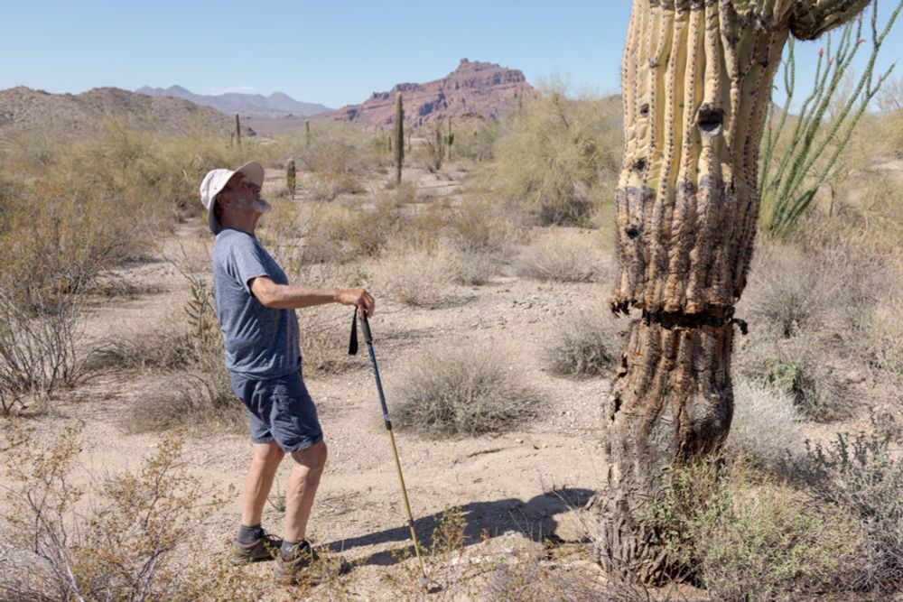
- ‘In late 2023, Mr. Pike created another map with more than 9,900 tiny saguaros. On this one, green signals good health and black means the cactus is dead. He’s trained about 40 people to find additional saguaros and monitor the ones already in the database.’ Beautiful #communityscience at work #GIS
- www.nytimes.com/2025/05/03/c... "in the summer of 2020, Mr. Pike watched the sky turn orange as the Bush fire burned 193,000 acres, killing roughly 80,000 saguaros." Included was the study site where I worked for my Master's degree. I haven't had the chance to go back to see the damage. 🌎 #ecology
- #Archaeology #pXRF #GIS #History #Hertiagestudies #Historyofslavery #Manillas ajuronline.org/uploads/Volu...
- 🔴 We’re live in 24 hours! 🔴 Join me, @rauljimenez.info, and several of my colleagues live tomorrow, May 8 at 9am PT / 12pm ET for Esri developer updates and a live Q&A. See you there! 🗺️ 👩💻 🔗 Event: www.esri.com/live/DevExpM... #Esri #GIS #ArcGIS
- 📍¿Sabes qué es el geoprocesamiento vectorial en #QGIS? Aprende a recortar, combinar y analizar capas paso a paso 👇 f.mtr.cool/sdrjqffqvn #QGIS #SIG #GIS #Geoprocesamiento #QGIS
- How many runways do you see for Gisborne airport (New Zealand) ? : The answer is on bigorre.org/aero/meteo/nzgs/en #gisborne #newzealand #gisborneairport #nzgs #gis #aviation #avgeek vl
- #GIS Answering Overwhelming Demand from Fans, Gushers Finally Drops First-Ever All Blue Pack stocktitan.net/news/GIS/answering-…
- In 1 week, #EsriCanada webinar: Made in #Canada - Your Guide to the #Community #Map of Canada tinyurl.com/4r9sbfxa #CommunityMaps #data #sharing #collaboration #basemaps #GIS #esri #mapping #arcgis #geography #GISchat #geospatial #geosky
- Our April newsletter 💌 ✏️ We have a new feature launching soon: the Annotator! Soon, you’ll be able to create a Record around a shape on the map – not just a single pin. Perfect for: • Contextual notes • Obscured or non-specific locations • Image direction + orientation #GIS #PGIS 🧵
- How many runways has Gisborne airport (New Zealand) ?” : The answer is on bigorre.org/aero/meteo/nzgs/en #gisborne #newzealand #gisborneairport #nzgs #gis #aviation #avgeek vl
- Tired of #GIS platforms that lock you in or slow you down? #Quarticle delivers cloud-native, #Kubernetes-powered geospatial analytics, fast, scalable, and vendor-free. Plus, it's built on open tech like #GeoServer & #QGIS. Ready to be in control? 👉 quarticle.ro
- Are you looking for a great role with a great social enterprise in Melbourne? Check out this new role with Australian Spatial Analytics in their Melbourne office for a CAD/BIM Team Lead gisjobs.com.au/job/cad-bim-... #GISjobsAustralia #ASA #MelbourneJobs #GIS
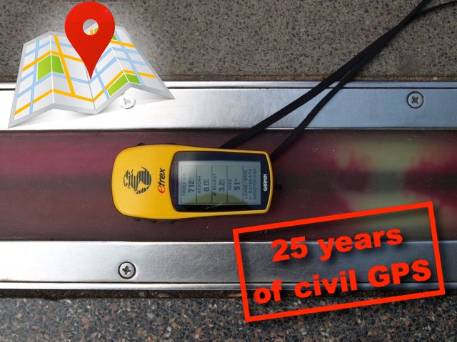
- GPS: 25 Jahre auch zivil ungestört / 25 years also undisturbed in civilian life geoobserver.de/2025/05/07/g... #gps #gistribe #gischat #fossgis #foss4g #OSGeo #spatial #geospatial #gis #geo #geoObserver pls RT
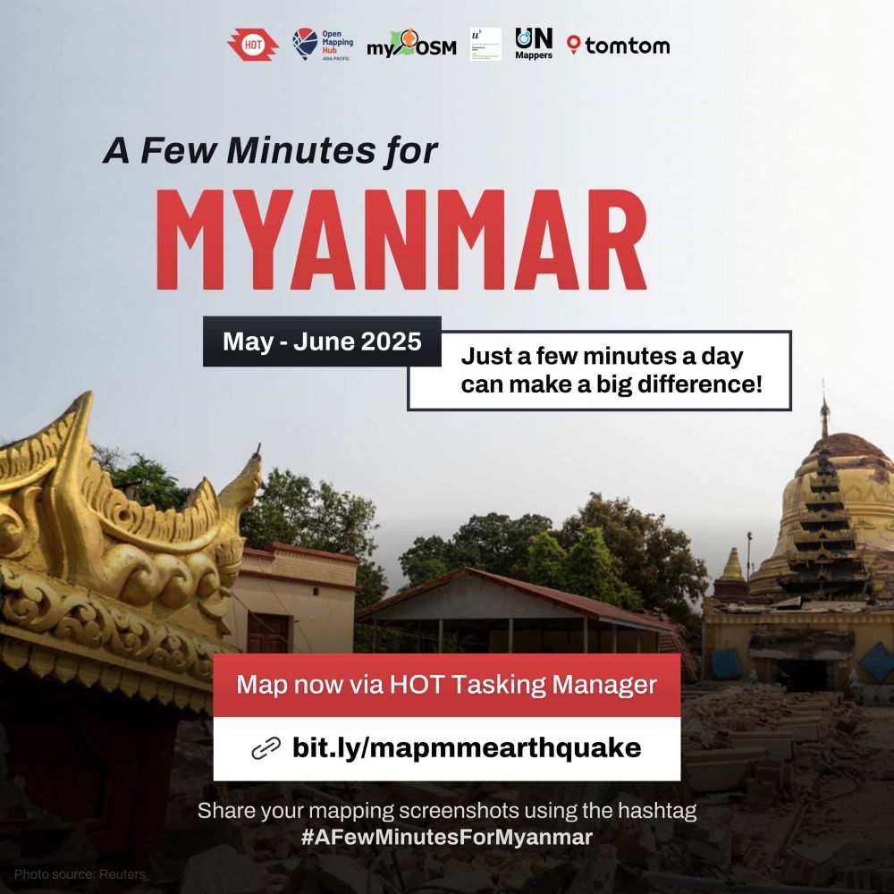
- A few minutes for Myanmar. A few minutes to make a difference. Join us in mappping affected areas from the #MyanmarEarthquake2025. Map now 👉🏼 lnkd.in/eZMKNvSU #AFewMinutesforMyanmar #UNMaps #UNMappers #humanitarianmapping #opendata #collaborativemapping #gis #crowdsourcing #volunteering
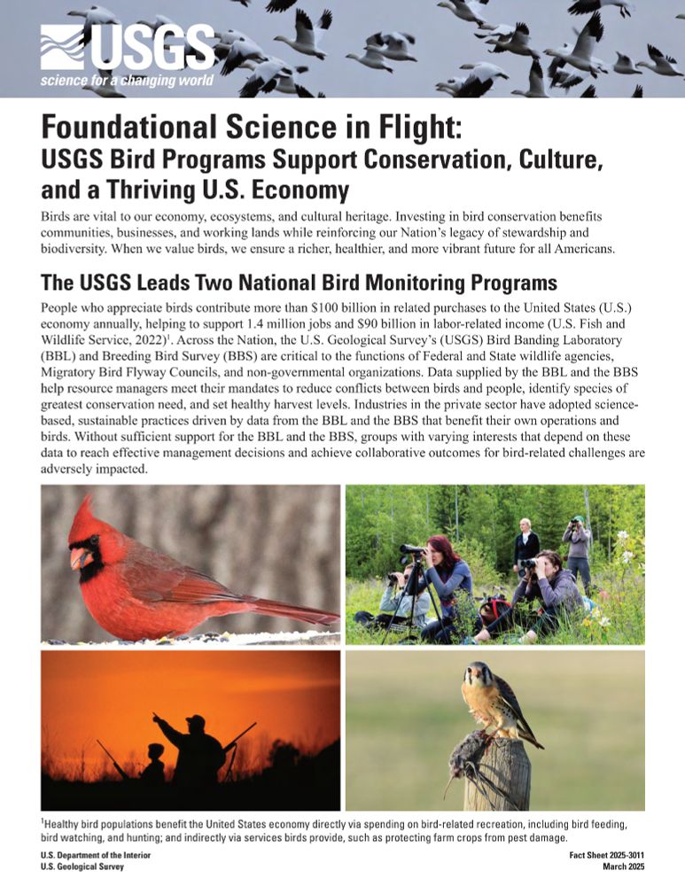
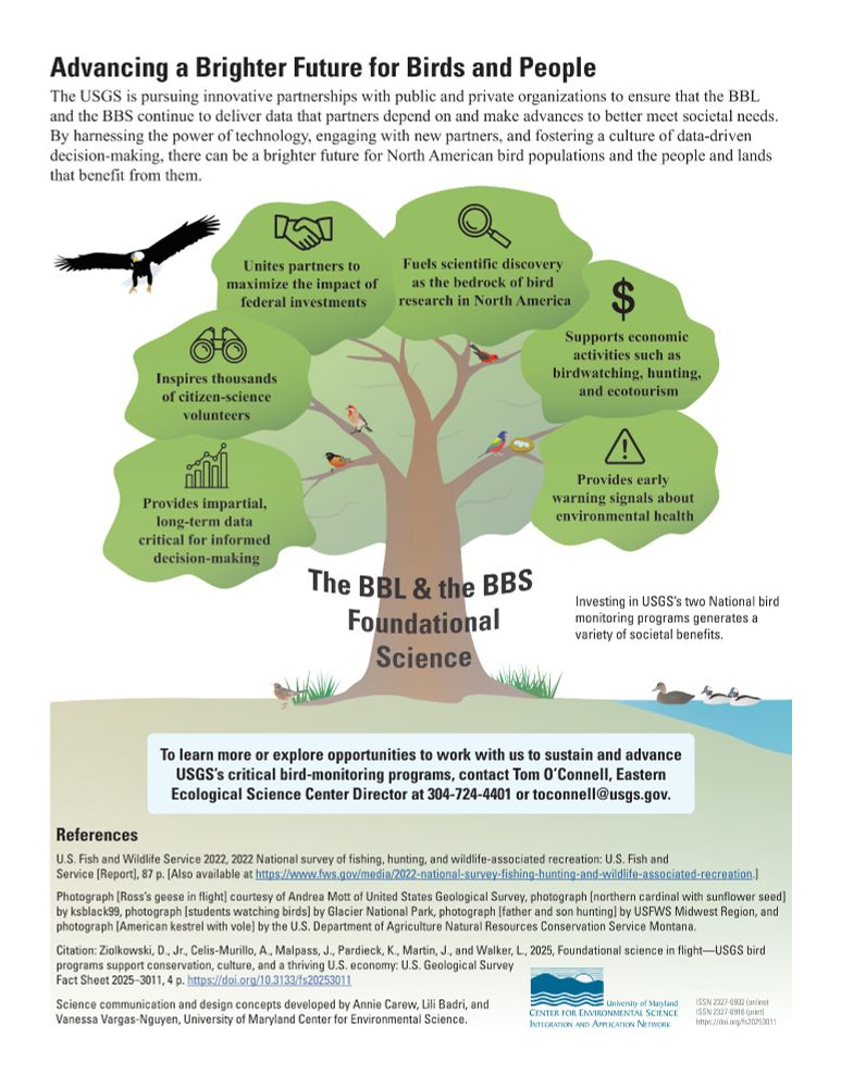
- #USGS #Bird Programs Support #Conservation, #Culture, and a Thriving #US #Economy - tinyurl.com/ycxxaf3t - #GIS #spatial #mapping #fedscience #ecosystem #heritage #resources #avian #wildlife #agency #migration #management #planning #spatialanalysis #spatiotemporal #flyway #history
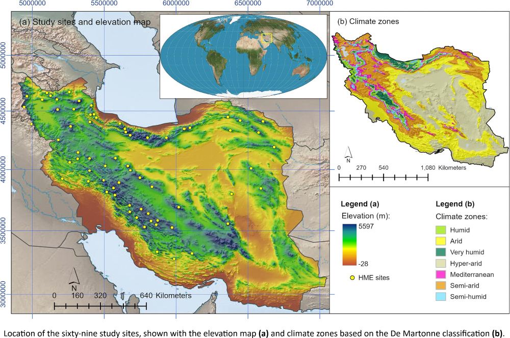
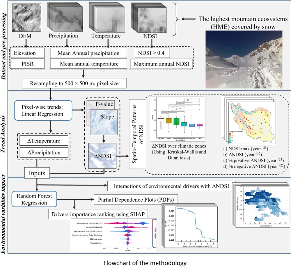
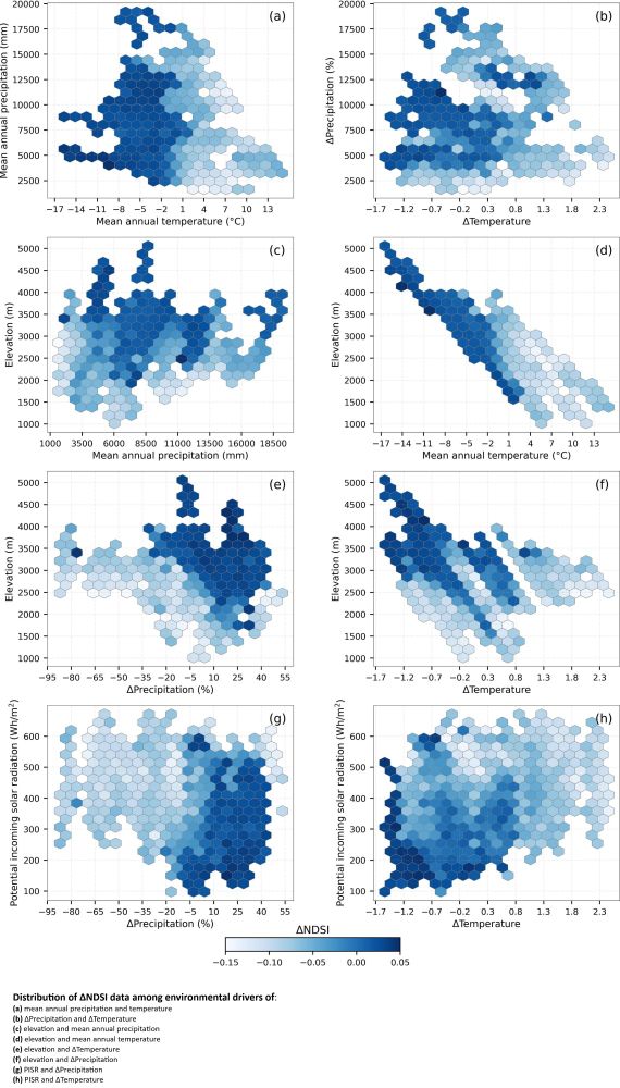
- Assessment Of #Snow #Cover #Dynamics & #Effects Of #Environmental Drivers In High #Mountain #Ecosystems - tinyurl.com/bhdddc8w - #GIS #spatial #mapping #remotesensing #ice #dynamics #climatechange #spatialanalysis #spatiotemporal #MODIS #model #modeling #extremeweather #water #hydrology #climate
- 🚨 Las nuevas versiones de #QGIS vienen sin las herramientas de SAGA, ¿lo sabías? Te mostramos cómo recuperarlas en solo 3 pasos: 1️⃣ Instala el complemento Saga NextGen. 2️⃣ Descarga #SAGA #GIS 3️⃣ Configura la ruta en “Procesos” Míralo aquí 👉
- Since I'm an adult I no longer watch afternoon cartoons (remember those) and watch stuff like this instead #gis #webmaps youtu.be/uTIK3x-1-6M?...
- Curso "online": Sistemas de Información Geográfica #GIS en la gestión del patrimonio y arqueología. Información: bit.ly/3Aqx7Dg Matricúlate ya: bit.ly/3EXETvN Universidad de Burgos. España. Certificado Guía didáctica: bit.ly/2G9eXss Tutorizado Acreditado educación y puntuable.
- Suuper pre-print from the big guys in spatial data and analysis: "Spatial Data Science Languages: commonalities and needs" A great and almost necessary read if you work with spatial data. arxiv.org/html/2503.16686v1 #GIS #GISChat
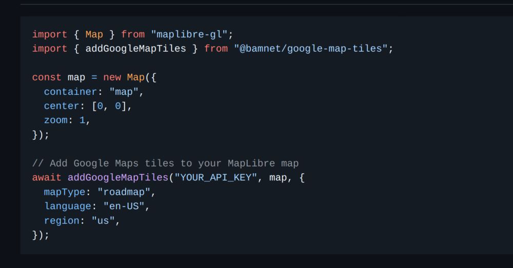
- Want to use Google Map Tiles with @maplibre.org? github.com/bamnet/googl... has got you covered. 🔄 Automatic session management ©️ Dynamic attribution handling 🎯 Google Maps logo placement Feedback, esp bugs, are very welcome. #MapLibre #gis #deno
- 🚨 New paper alert 🚨. My former senior thesis student and I worked on this together. We did a comprehensive assessment of potential tornado and lightning exposure to large outdoor gatherings in the US. #disaster #hazard #GIS #wx #sports #festival journals.ametsoc.org/view/journal...
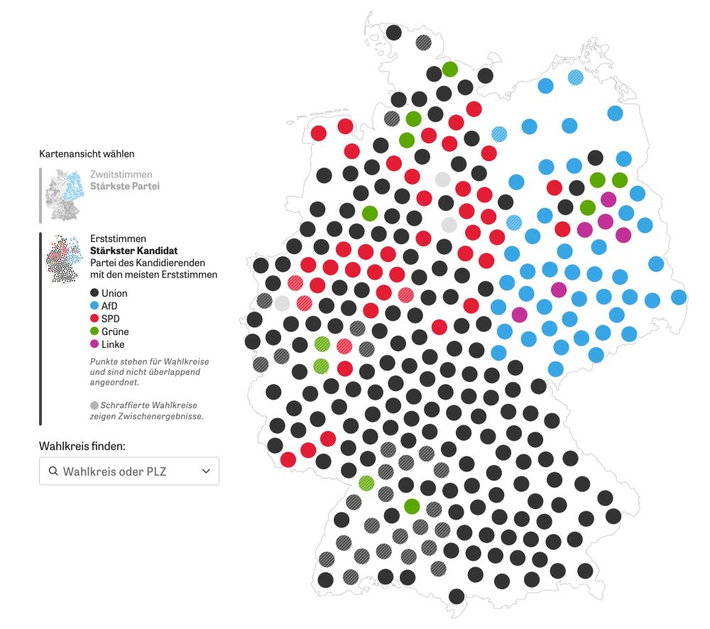
- For the German election we wanted to use a cartogram of German election districts but didn't find anything good, so we created our own. Here's a little nerd thread how the final algorithm worked 🤓 🧵 #gis #cartogram #election #datavis #cartography
- Attention data journalists (and others 😃) who want to use geospatial data with R for story telling: #RStats #RSpatial #DDJ #RShiny #GIS ⬇️⬇️⬇️
- The latest version of the {mapgl} #rstats package is now released, supporting scrollytelling-style story maps! Build richly interactive map stories from your R data pipelines using @Mapbox or @maplibre as your backend. Learn how in the new vignette: walker-data.com/mapg...
- Back to counting quarry pits again #Archaeology #GIS
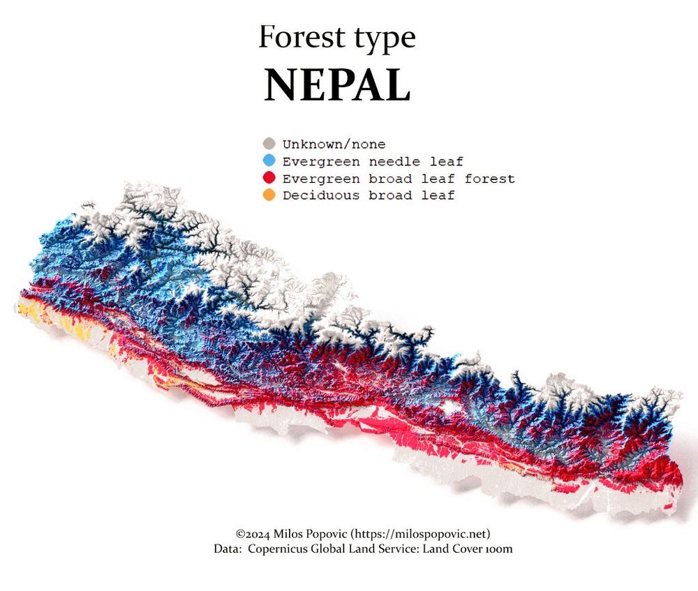
- Take a look at Nepal's🇳🇵 forest types from a new perspective with my 3D map. For those interested in GIS and environmental science, I've put together a tutorial on how to create these maps. Access it here: youtu.be/MFbJrjpf_2M #maps #dataviz #GIS #Nepal #Forest #rayshader #rstats