Search
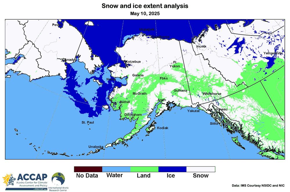
- Low elevation snow melt progressing across Alaska and vicinity. The May 10 IMS analysis from the National Ice Center shows snow-free ground appearing in the Yukon Flats and up the Koyukuk River valley. North Slope and most of NW Arctic Borough snow melt has barely started. #akwx #Spring2025 #Snow
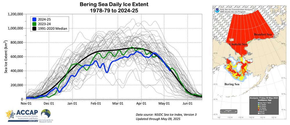
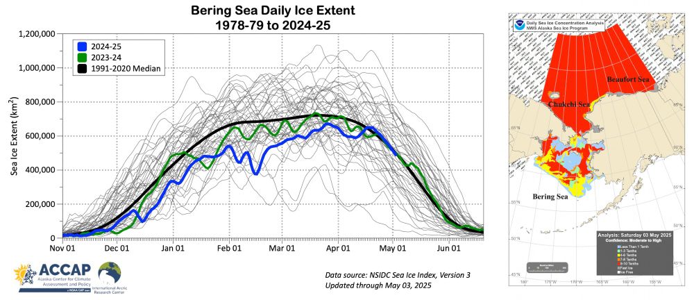
- Sea ice extent in the Bering Sea is decreasing rapidly and right on schedule. The "Swiss cheese" pattern of ice melt, with large areas of open water north of the ice edge is also common, though this year is more extreme than some. #akwx #Arctic #SeaIce @zacklabe.com @climatologist49.bsky.social
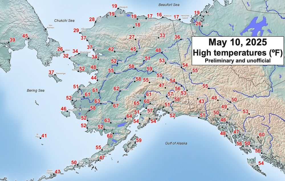
- High temperatures (ºF) in and around Alaska on Saturday, May 10, 2025. Very mild across the western Interior/southwest Alaska with 67F at Sleetmute the highest reliable temp in Alaska so far this year. Another cool day in Southeast and North Slope remains notably cooler than normal. #akwx #weather
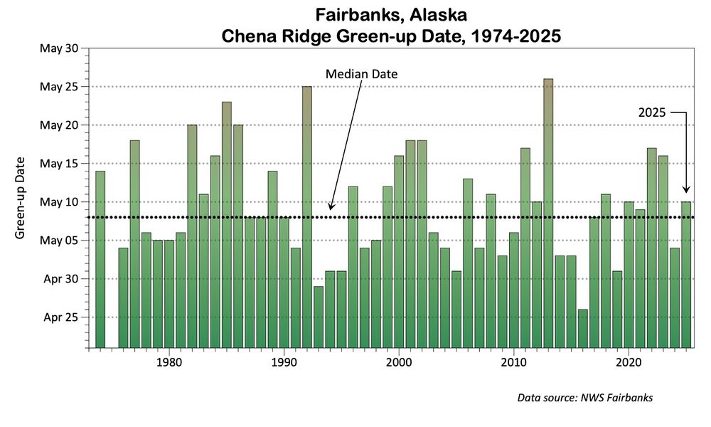
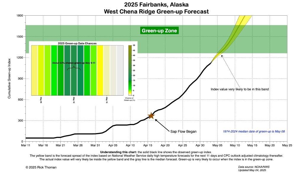
- NWS Fairbanks reported "green-up" on Chena Ridge near Fairbanks on Saturday. This is six days later than last year but very close to the 50-year median. There is no long term trend in green-up date over that time. #akwx #Spring2025 @akbecca70.bsky.social @alasjules.bsky.social
- It’s an #AlaskaSky kind of day in Fairbanks. A lot of people at Aviation Day. 55F and deep blue skies. #akwx
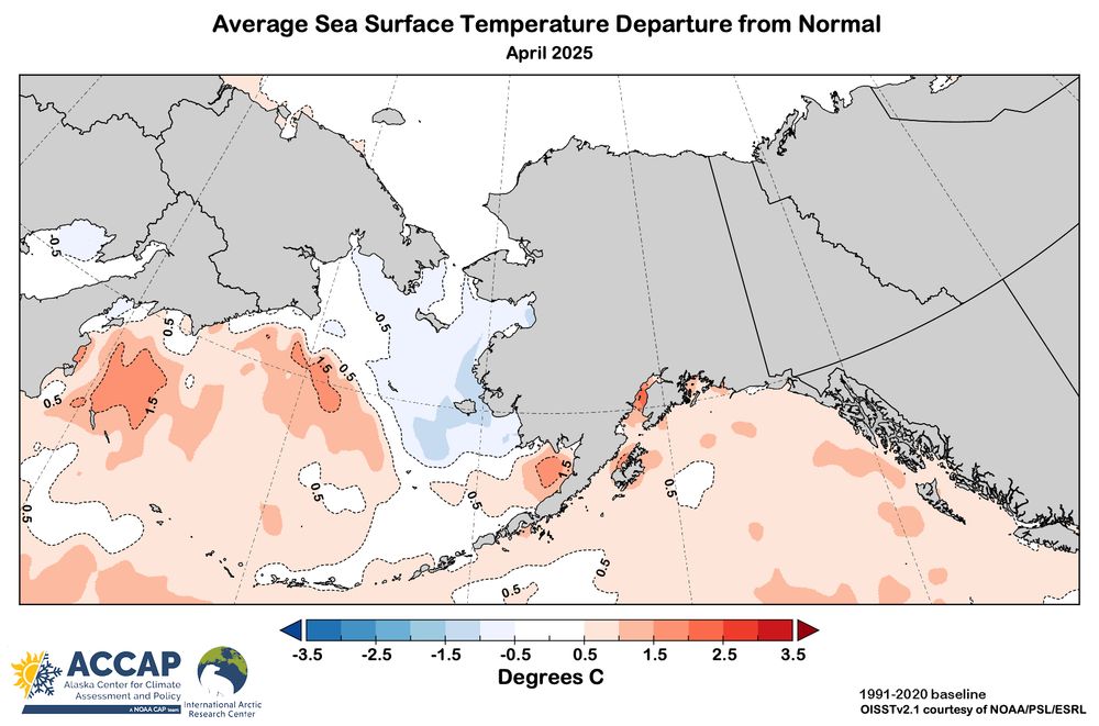
- Alaska and vicinity April sea surface temperature departures from 1991-2020 average from the NOAA high-resolution OISSTv2.1 dataset. Except for sea ice influenced areas, SSTs were above normal in the Bering Sea as well virtually the entire Gulf of Alaska. #akwx #Arctic #SST
- High temperatures (ºF) in and around Alaska on Friday. A mild day across the western and central Interior and southwest and southcentral Alaska, with many places seeing the highest temperatures of the year thus far. Cool and rainy in Southeast. #akwx #weather @climatologist49.bsky.social
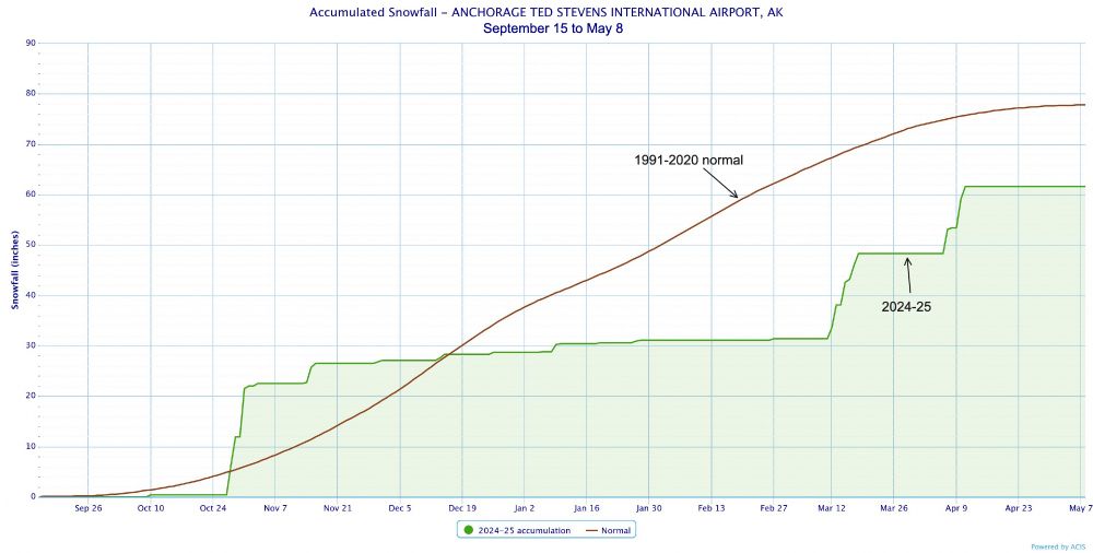
- Anchorage airport snowfall for 2024-25 winter very likely total 61.6 inches (156cm), the lowest total since 2017-18. More than 90 percent of the total fell outside of Dec-Feb. The 1991-2020 normal seasonal snowfall is 77.9 inches (198cm). Graphic from the endangered xmACIS. #akwx #climate #Snow
- High temperatures (ºF) in and around Alaska on Thursday. Coolish with some rain much of Southcentral and Southeast. A bit milder northern and central Interior. #akwx #weather @climatologist49.bsky.social
- High temperatures (ºF) in and around Alaska on Wednesday. Chilly day in Southcentral and the central and eastern Alaska Range. Gulkana set a May 7 record for lowest max temperature (37F). in contrast, another mild day in the western Interior. #akwx #weather @climatologist49.bsky.social
- The NWS automated weather observation system at the Utqiaġvik airport, the largest community and hub of the North Slope, hasn't reported complete observations, or at all overnight, since August 2023 because of a communications problem that was FINALLY resolved Wednesday late morning. #akwx #Alaska
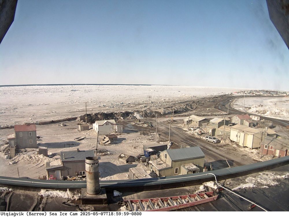
- Nice to have the Utqiaġvik sea ice cam back online. Wednesday mostly sunny at 7pm, 25F and northeast wind 15 mph. Open water visible at the edge of the fast ice on the left side of the image. #akwx #Spring2025
- McGrath, Alaska joins Kotzebue with no more upper air observations. Yakutat and Bethel down to one launch a day. Shemya is a Dept. of Defense site. More reductions coming. #akwx #weather #NOAA @climatologist49.bsky.social
- This animation from May 5, 2025 shows the VIIRS Blowing Snow product, looking at the North Slope of Alaska east of Utqiagvik. Blowing snow can be seen around Prudhoe Bay, highlighted in yellow. Clouds over the ocean are show in blue/cyan, and snow and ice is colored red. #akwx
- High temperatures (ºF) in and around Alaska on Tuesday. More seasonable across the North Slope. Cooler than normal Alaska Peninsula as well as the northern and eastern Interior and Yukon Territory. #akwx #weather @climatologist49.bsky.social
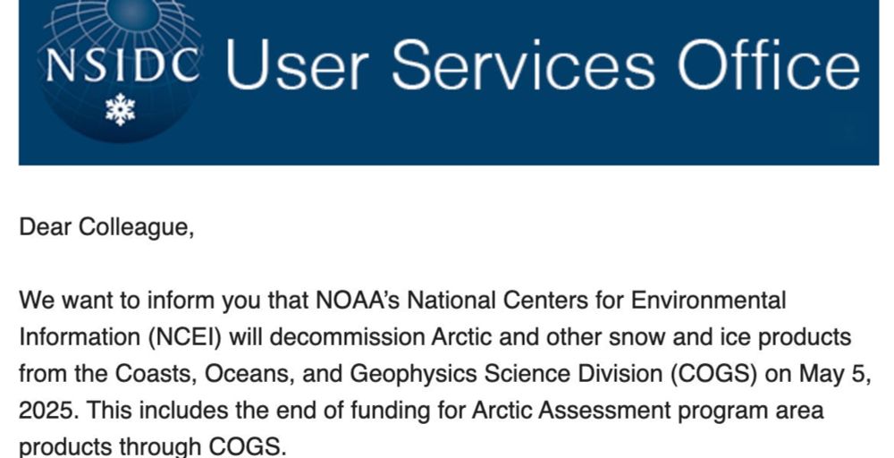
- Post up on the Alaska and Arctic Climate Newsletter on defunding of key US sea ice data sets. #akwx #Arctic #SeaIce alaskaclimate.substack.com/p/loss-and-d...
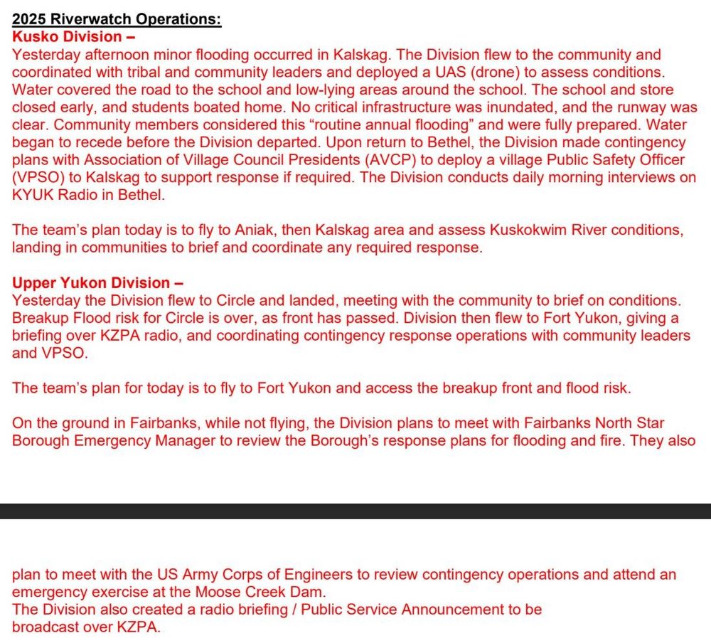
- As Interior Alaska's rivers go through their annual breakup cycle, there was minor flooding in Kalskag yesterday, but so far, no major issues. The Yukon River's breakup front is approaching Fort Yukon. #akwx
- High temperatures (ºF) in and around Alaska on Monday. A bit milder across Southcentral and slight moderation on the North Slope. Mildest day of the year so far at Nome due to persistent offshore winds. #akwx #weather @climatologist49.bsky.social
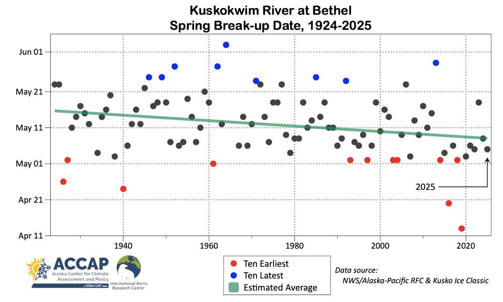
- Ice broke on the Kuskokwim River at Bethel at 410pm AKDT Monday. This is five days earlier than the average break-up date over the past 50 years. The typical break-up nowadays is 8 days earlier than it was in the 1920s. #akwx #Spring2025 @markspringer.bsky.social @egw-b12.bsky.social
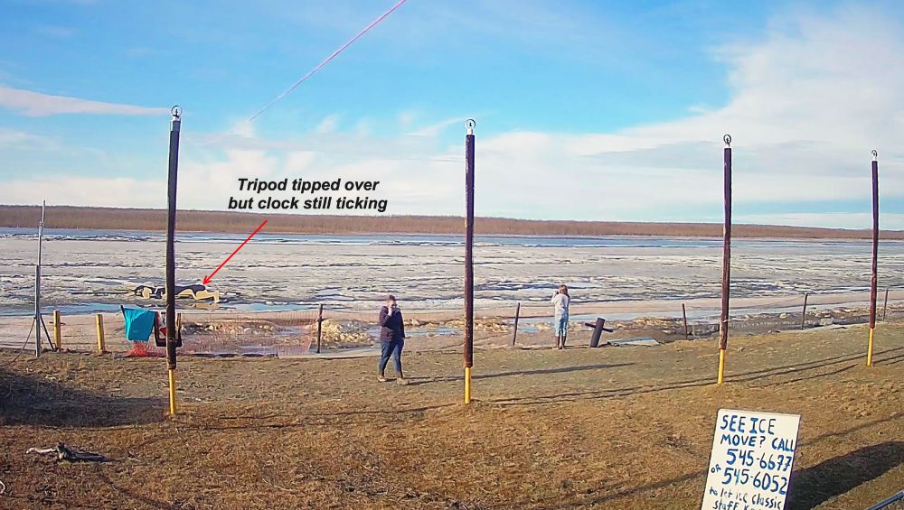
- The ice in Kuskokwim River at Bethel is still holding Monday morning but the tripod has tipped over. The typical date of break-up over the past 30 years is about May 10. Photo courtesy Kuskokwim Ice Classic. #akwx #Kusko #Spring2025 @markspringer.bsky.social @climatologist49.bsky.social
- High temperatures (ºF) in and around Alaska on Sunday. A bit milder than Saturday in many areas except cooler on the Alaska Peninsula, Kodiak and Kenai Peninsula. #akwx #weather @climatologist49.bsky.social
- Total #SeaIce extent in the Bering Sea is very close to the 1991-2020 median for early May in NSIDC data, but the distribution of the ice is odd. The ice pack is near the furthest south extent of the season in the central Bering Sea…but the northern Bering is increasingly open water. #akwx #Arctic
- High temperatures (ºF) in and around Alaska on Saturday. Chilly across most of Alaska. Based on the state-wide temperature index this was the coolest day relative to normal in nearly four weeks. Only areas above normal were the SE Interior into the Yukon. #akwx #weather @climatologist49.bsky.social
- For Fairbanks folks: our little green-up model as of Sunday morning shows a 65 percent chance that West Chena Ridge green-up will be May 8-11. Those with birch allergies: pollen release typically starts a few days before green-up and peaks a few days after green-up. #akwx #Spring2025 #AlaskaSky
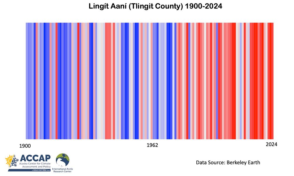
- Climate stripes for Lingít Aaní (Tlingit county) across Southeast Alaska into NW Canada, 1900 to 2024. Data from Berkeley Earth and processing made possible with code by @climatologist49.bsky.social. #akwx #ClimateStripes #Climate @spiraledu.bsky.social @seakgal.bsky.social @seachanger.bsky.social
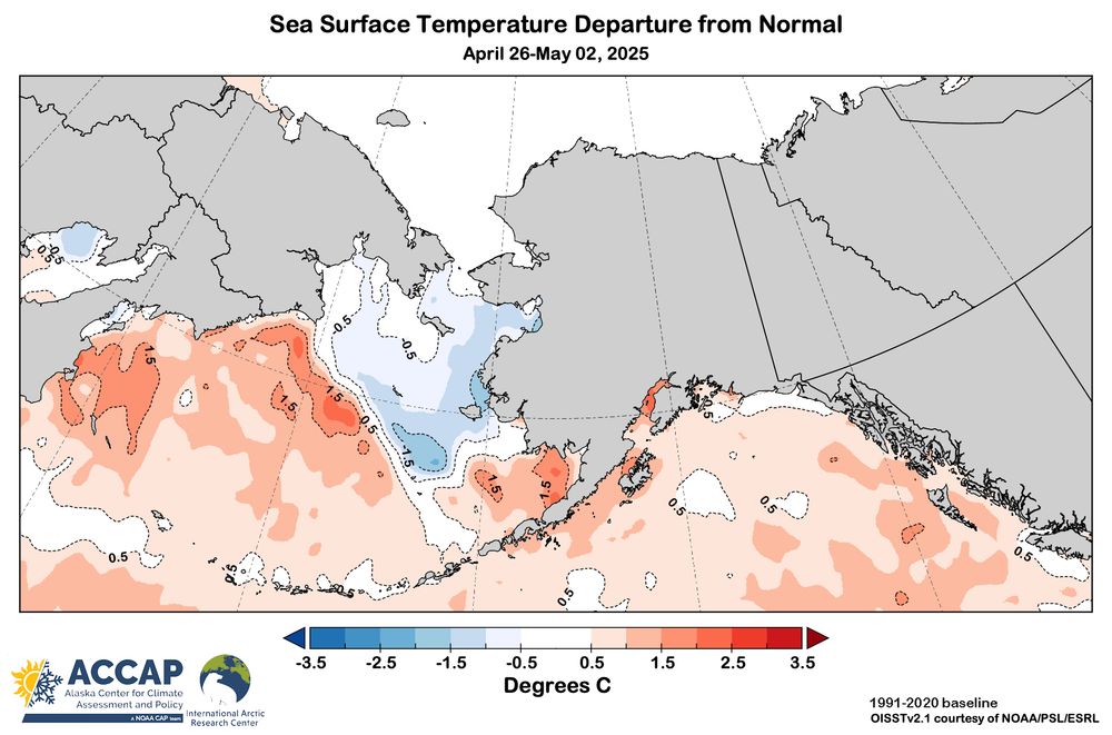
- Sea surface temperature relative to the 1991-2020 average for the week ending May 2 in the seas around Alaska. Except for the sea ice influenced areas in the northern and eastern Bering Sea, sea surface temperatures are well above normal in most areas. Data courtesy NOAA/PSL/ESRL. #akwx #Arctic #SST
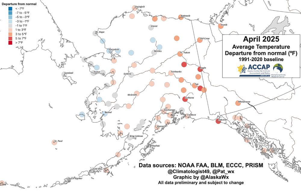
- April 2025 over most of Alaska saw a milder than normal April overall. Eagle, Northway, Tok and Yakutat all had a "top three" mildest April. Some places in western Alaska and the northern Interior finished up on the cool side, though not dramatically so. #akwx #Climate @climatologist49.bsky.social
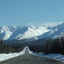
- Saturday 645am and it's 31F (-0.6C) with snow accumulating on Cleary Summit at Mile 21 Steese Highway, northeast of Fairbanks (elevation 2270 feet/690 meters MSL). Early May snow is common at this elevation. #akwx #Spring2025 #snow @carrieinfbx.bsky.social @bs.mivox.net @akbecca70.bsky.social
- High temperatures (ºF) in and around Alaska on Friday. Continued unseasonably cold on the North Slope and especially in the Brooks Range. In contrast, mildest day of the season in many areas in the central and southern Yukon Territory and northwest BC. #akwx #weather @climatologist49.bsky.social
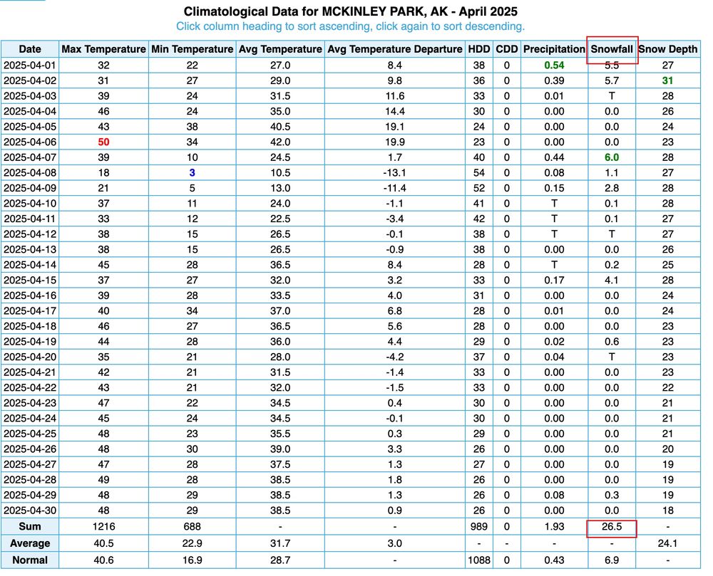
- Denali National Park #Alaska HQ has made climate observations for more than a century. Last month 26.5 inches (67.3cm) snow is the 2nd highest April #snow total. Highest remains the presumably untouchable 92.3 inches (234.4cm) in April 1948. Graphic from the threatened xmACIS website. #akwx #climate
- River ice break-up is underway in northwest North America. So far no serious flooding. I’ve got the early results of this year’s break-up in the climate scale context in a new post in the Alaska and Arctic Climate newsletter. #akwx #ytwx #ClimateChange alaskaclimate.substack.com/p/spring-202...